GEN 3.2 AERONAUTICAL CHARTS
1 RESPONSIBLE SERVICES
| Annex 4 | – | Aeronautical Charts, Eleventh Edition 2009. |
| Doc 8168-OPS/611 | – | Aircraft Operations, Volume II - Construction of Visual and Instrument Flight Procedures, Fifth Edition 2006. |
2 MAINTENANCE OF CHARTS
3 AVAILABILITY OF CHARTS
4 AERONAUTICAL CHART SERIES AVAILABLE
- World Aeronautical Chart - ICAO;
- Aerodrome Chart - ICAO;
- Aerodrome Obstacle Chart - ICAO Type A (for each runway);
- Aerodrome Obstacle Chart - ICAO Type B;
- Precision Approach Terrain Chart - ICAO;
- Enroute Chart - ICAO;
- Area Chart - ICAO;
- Standard Departure Chart - Instrument (SID) - ICAO;
- Standard Arrival Chart - Instrument (STAR) - ICAO;
- Instrument Approach Chart - ICAO (for each runway and procedure type);
- Visual Approach Chart - ICAO
- World Aeronautical Chart - ICAO 1: 1 000 000
This series is constructed on Lambert Conformal Conic Projection with two standard parallels at 0 deg 40 min and 3 deg 20 min. The spheroid is World Geodetic System 1984 (WGS84). The aeronautical data shown have been kept to a minimum, consistent with the use of the chart for visual air navigation. It includes a selection of aerodromes, significant obstacles, elements of the ATS system, prohibited, restricted and danger areas, and radio navigation aids. The chart provides information to satisfy visual air navigation and is also used as a pre-flight planning chart.
- Aerodrome Chart - ICAO
This chart contains detailed aerodrome data to provide flight crews with information that will facilitate the ground movement of aircraft:
- from the aircraft stand to the runway; and
- from the runway to the aircraft stand;
It also provides essential operational information at Singapore Changi Airport and Seletar Aerodrome.
- Aerodrome Obstacle Chart - ICAO Type A (operating limitations)
This chart contains detailed information on obstacles in the take-off flight path areas of Singapore Changi Airport, Seletar Aerodrome and Paya Lebar Airport. It is shown in plan and profile view. This obstacle information provides the data necessary to enable an operator to comply with the operating limitations of ICAO Annex 6, Parts l and ll, Chapter 5.
- Aerodrome Obstacle Chart - ICAO Type B
This chart is produced to assist in the determination of critical heights for Singapore Changi Airport and Seletar Aerodrome.
- Precision Approach Terrain Chart - ICAO
This chart provides detailed terrain profile information within a defined portion of the final approach so as to enable aircraft operating agencies to assess the effects of the terrain on decision height determination by the use of radio altimeters. This chart is produced for the precision approach Cat II runways at Singapore Changi Airport.
- Enroute Chart - ICAO
This chart is produced for the entire Singapore FIR. The aeronautical data include all aerodromes, prohibited, restricted and danger areas and the air traffic services system in detail. This chart provides the flight crew with information to facilitate navigation along ATS routes in compliance with air traffic services procedures.
- Area Chart - ICAO
This chart is produced when the air traffic services routes or position reporting requirements are complex and cannot be shown on the En-route Chart - ICAO. It shows, in more detail, those aerodromes that affect terminal routings, prohibited, restricted and danger areas and the air traffic services system. This chart provides the flight crew with information to facilitate the various phases of instrument flight:
- the transition between the en-route phase and the approach to an aerodrome;
- the transition between the take-off/missed approach and the en-route phase of flight; and
- flights through areas of complex ATS routes or airspace structure.
- Standard Departure Chart - Instrument (SID) - ICAO
This chart is produced whenever a standard departure route - instrument has been established and cannot be shown with sufficient clarity on the Area Chart - ICAO.
The aeronautical data shown include the aerodrome of departure, aerodrome(s) which affect the designated standard departure route-instrument, prohibited, restricted and danger areas and the air traffic services system. This chart provides the flight crew with information that will enable them to comply with the designated standard departure route-instrument from the take-off phase to the en-route phase.
- Standard Arrival Chart - Instrument (STAR) - ICAO
This chart is produced whenever a standard arrival route - instrument has been established and cannot be shown with sufficient clarity on the Area Chart - ICAO.
The aeronautical data shown include the aerodrome of landing, aerodrome(s) which affect the designated standard arrival route-instrument, prohibited, restricted and danger areas and the air traffic services system. This chart provides the flight crew with information that will enable them to comply with the designated arrival route-instrument from the en-route phase to the approach phase.
- Instrument Approach Chart - ICAO
This chart is produced for all aerodromes used by civil aviation where instrument approach procedures have been established. A separate Instrument Approach Chart - ICAO has been provided for each approach procedure.
The aeronautical data shown include information on aerodromes, prohibited, restricted and danger areas, radio communication facilities and navigation aids, minimum sector altitude, procedure track portrayed in plan and profile view, aerodrome operating minima, etc.
This chart provides the flight crew with information that will enable them to perform an approved instrument approach procedure to the runway of intended landing including the missed approach procedure and where applicable, associated holding patterns.
- Visual Approach Chart - ICAO
This chart is produced for aerodromes used by civil aviation where:
- only limited navigation facilities are available; or
- radio communication facilities are not available; or
- no adequate aeronautical charts of the aerodrome and its surroundings at 1:500 000 or greater scale are available; or
- visual approach procedures have been established
The aeronautical data shown include information on aerodromes obstacles, designated airspace, visual approach information, radio navigation aids and communication facilities, as appropriate.
5 LIST OF AERONAUTICAL CHARTS AVAILABLE
| GEN 3.2.5 LIST OF AERONAUTICAL CHARTS AVAILABLE | |||||
|---|---|---|---|---|---|
| Title of Chart Series | Scale | Name and/or number | Price ($) | Date | |
World Aeronautical Chart ICAO (WAC) | 1:1 000 000 | WAC 2860 | In AIP | 30 JAN 20 | |
Enroute Chart ICAO (ENRC) | ERC 6-1 | In AIP | 15 AUG 19 | ||
Instrument Approach Chart ICAO (IAC) | Singapore Changi | ||||
| 1:400 000 | RWY 02L - ICW ILS/DME | AD-2-WSSS-IAC-1 | In AIP | 10 OCT 19 | |
| 1:400 000 | RWY 02C - ICE ILS/DME | AD-2-WSSS-IAC-2 | In AIP | 10 OCT 19 | |
| 1:400 000 | RWY 20R - ICH ILS/DME | AD-2-WSSS-IAC-5 | In AIP | 10 OCT 19 | |
| 1:400 000 | RWY 20C - ICC ILS/DME | AD-2-WSSS-IAC-6 | In AIP | 10 OCT 19 | |
| 1:400 000 | RWY 20C - VTK DVOR/DME | AD-2-WSSS-IAC-7 | In AIP | 30 JAN 20 | |
| 1:400 000 | RWY 02L - RNAV(GNSS) | AD-2-WSSS-IAC-9 | In AIP | 10 OCT 19 | |
| 1:400 000 | RWY 02C - RNAV(GNSS) | AD-2-WSSS-IAC-10 | In AIP | 10 OCT 19 | |
| 1:400 000 | RWY 20R - RNAV(GNSS) | AD-2-WSSS-IAC-11 | In AIP | 10 OCT 19 | |
| 1:400 000 | RWY 20C - RNAV(GNSS) | AD-2-WSSS-IAC-12 | In AIP | 10 OCT 19 | |
| Paya Lebar | |||||
| 1:400 000 | RWY 20 - PU DVOR/DME | AD-2-WSAP IAC-1 | In AIP | 10 OCT 19 | |
| 1:400 000 | RWY 02 - PU DVOR/DME | AD-2-WSAP IAC-2 | In AIP | 30 JAN 20 | |
| 1:400 000 | RWY 20 - IPS ILS/DME | AD-2-WSAP IAC-3 | In AIP | 10 OCT 19 | |
| 1:400 000 | RWY 02 - IPN ILS/DME | AD-2-WSAP IAC-4 | In AIP | 30 JAN 20 | |
| 1:400 000 | RWY 02 - RNAV(GNSS) | AD-2-WSAP-IAC-5 | In AIP | 10 OCT 19 | |
| 1:400 000 | RWY 20 - RNAV(GNSS) | AD-2-WSAP-IAC-6 | In AIP | 10 OCT 19 | |
Visual Approach Chart ICAO (VAC) | 1:400 000 | Singapore Changi | AD-2-WSSS-VAC-1 | In AIP | 10 OCT 19 |
| Seletar | |||||
| 1:100 000 | RWY 03 | AD-2-WSSL-VAC-1 | In AIP | 05 DEC 19 | |
| 1:100 000 | RWY 21 | AD-2-WSSL-VAC-2 | In AIP | 05 DEC 19 | |
| 1:100 000 | RWY 03 | AD-2-WSSL-VAC-3 | In AIP | 05 DEC 19 | |
| 1:100 000 | RWY 21 | AD-2-WSSL-VAC-4 | In AIP | 05 DEC 19 | |
| Visual Departure Chart | Seletar | ||||
| 1:100 000 | RWY 03 | AD-2-WSSL-VDC-1 | In AIP | 30 JAN 20 | |
| 1:100 000 | RWY 21 | AD-2-WSSL-VDC-2 | In AIP | 30 JAN 20 | |
Aerodrome Chart ICAO (AC) | Singapore Changi | AD-2-WSSS-ADC-2 | In AIP | 21 | |
| Seletar | AD-2-WSSL-ADC-1 | In AIP | 26 MAR 20 | ||
| Paya Lebar | AD-2-WSAP-ADC-1 | In AIP | 12 NOV 15 | ||
Aerodrome Obstacle Chart ICAO TYPE A (AOC) | Singapore Changi | ||||
| 1:10 000 | RWY 20R/02L | AD-2-WSSS-AOC-1 | In AIP | 07 DEC 17 | |
| 1:10 000 | RWY 20C/02C | AD-2-WSSS-AOC-2 | In AIP | 29 MAR 18 | |
| Seletar | |||||
| 1:10 000 | RWY 03/21 | AD-2-WSSL-AOC-1 | In AIP | 17 AUG 17 | |
| Paya Lebar | |||||
| 1:20 000 | RWY 20/02 | AD-2-WSAP-AOC-1 | In AIP | 10 NOV 16 | |
Aerodrome Obstacle Chart ICAO TYPE B (AOC) | Singapore Changi | ||||
| 1:20 000 | RWY 02L/20R and 02C/20C | AD-2-WSSS-AOC-3 | In AIP | 13 SEP 18 | |
| Seletar | |||||
| 1:20 000 | RWY 03/21 | AD-2-WSSL-AOC-2 | In AIP | 08 NOV 18 | |
Precision Approach Terrain Chart ICAO (PATC) | Singapore Changi | ||||
| 1:2 500 | RWY 02L | AD-2-WSSS-PATC-1 | In AIP | 10 OCT 19 | |
| 1:2 500 | RWY 20C | AD-2-WSSS-PATC-2 | In AIP | 01 FEB 18 | |
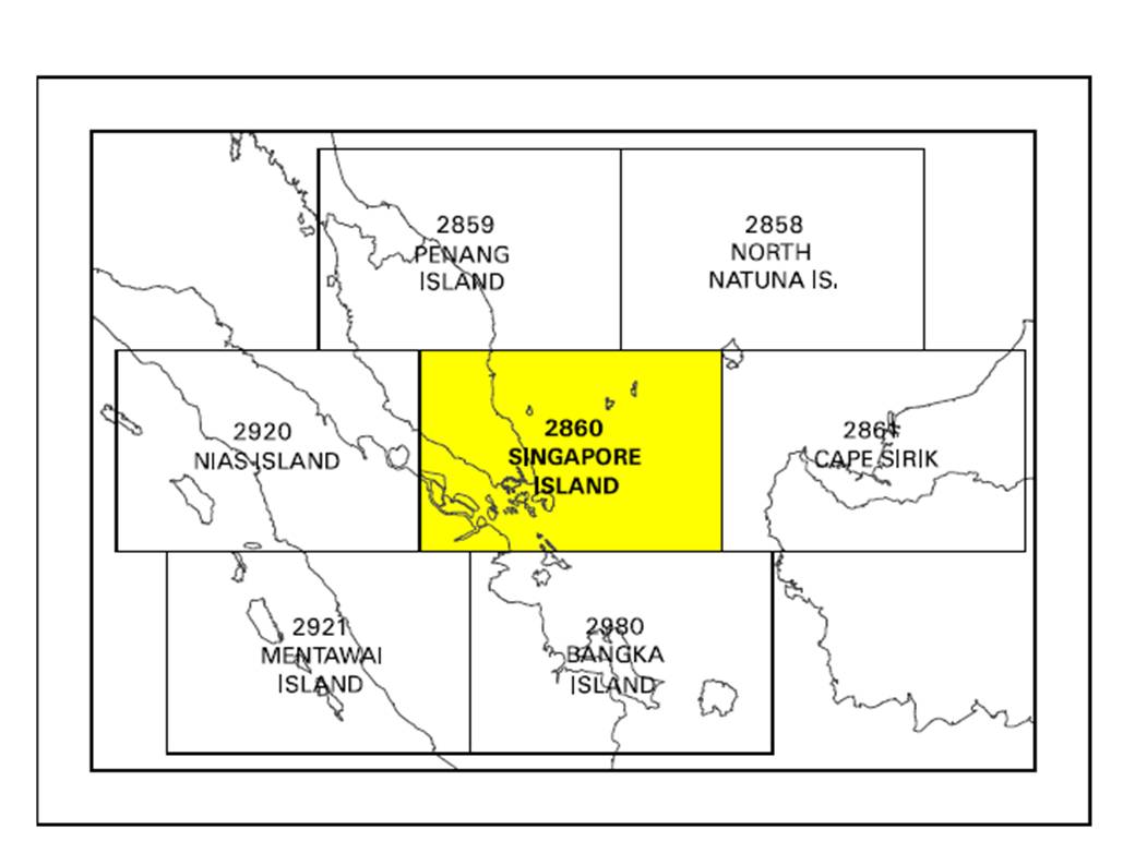
6 INDEX TO THE WORLD AERONAUTICAL CHART (WAC) - ICAO 1:1 000 000
7 CORRECTIONS TO CHARTS NOT CONTAINED IN THE AIP
| Identification of charts | Location on the chart where the correction has to be made | Precise details of the corrections to be made |
|---|---|---|
| NIL | NIL | NIL |