WSSL — SINGAPORE / SELETAR
WSSL AD 2.1 AERODROME LOCATION INDICATOR AND NAME
WSSL — SINGAPORE / SELETAR
WSSL AD 2.2 AERODROME GEOGRAPHICAL AND ADMINISTRATIVE DATA
| 1 | ARP Coordinates and Site at AD | 012501.04N 1035203.52E |
| 2 | Direction and distance from (city) | 006°, 14.6km from city centre (The Fullerton Hotel, Singapore) |
| 3 | Elevation/Reference Temperature | 14 M (46ft) / 33.5°C |
| 4 | Geoid Undulation | 9.78 M |
| 5 | MAG VAR | 0°26' E (2015) |
| 6 | AD Administration, Address, Telephone, Telefax, AFS | Address: TEL: (65)64812909, Fax: (65)64833044 (AIS) AFS: WSSLYDYX |
| 7 | Types of Traffic Permitted | IFR and VFR |
| 8 | Remarks |
|
WSSL AD 2.3 OPERATIONAL HOURS
| 1 | Aerodrome Administration | H24 | 5 | ATS Reporting Office | H24 |
| 2 | Customs and Immigration | H24 | 6 | MET Briefing Office | H24 |
| 3 | Health and Sanitation | H24 | 7 | Air Traffic Services | H24 |
| 4 | AIS Self-Briefing Office | H24 | 8 | Apron Control Office | H24 |
WSSL AD 2.4 HANDLING SERVICES AND FACILITIES
| 1 | Cargo Handling Facilities | Provided by handling agent. |
| 2 | Fuel / Oil Types | AVGAS 100LL, JET A1 |
| 3 | Fuelling Facilities / Capacity | SUN/MON to THU/FRI BTN 2330-1400; SAT, SUN and Public holidays BTN 0030-0930 Contact during operating hours: TEL: (65)68538320 (Operations Room) Contact after operating hours: TEL: (65)91130816 (H24 Operations Mobile) FAX: (65)64839246 Group email: GX-SAV-Seletar-Operations24by7@shell.com PPP link: http://www.shell.com/business-customers/aviation/ppp.html |
| 4 | Hangar space for visiting aircraft | By arrangement with handling agent. |
| 5 | Repair facilities for visiting aircraft | By arrangement with handling agent. |
| 6 | Remarks | NIL |
WSSL AD 2.5 PASSENGER FACILITIES
| 1 | Hotels | NIL |
| 2 | Restaurants | Public area of terminal building |
| 3 | Transportation | Handling agent provides its own transport service for passengers and crew between airport and city. Public buses and private hired taxis are available at airport terminal. |
| 4 | Medical Facilities | NIL |
| 5 | Bank and Post Office | NIL |
| 6 | Tourist Office | NIL |
| 7 | Remarks | Internet address : http://www.seletarairport.com / for airport and flight information, facilities and services. |
WSSL AD 2.6 RESCUE AND FIRE FIGHTING SERVICES
| 1 | AD category for fire fighting | CAT7 (No facilities for foaming of runways). |
| 2 | Rescue equipment | Adequately provided as recommended by ICAO. |
| 3 | Capability for removal of disabled aircraft | Up to B757-200. Contact Seletar Airside Operations at: +65 64815077 or +65 97533361 |
| 4 | Remarks | All Airport Emergency Service personnel are trained in rescue and fire-fighting as well as medical first-aid. |
WSSL AD 2.7 SEASONAL AVAILABILITY - CLEARING
| The aerodrome is available throughout the year |
WSSL AD 2.8 APRONS, TAXIWAYS AND CHECK LOCATIONS/POSITIONS DATA
| 1 | Apron surface and strength | Surface: Bituminous concrete (aircraft stand C7) Strength: PCN44/F/C/X/T Surface: Concrete (all other aircraft stands) Strength: PCN41/R/C/W/T | ||||||||
| 2 | Taxiway width, surface and strength |
| ||||||||
| 3 | Remarks : NIL | |||||||||
WSSL AD 2.9 SURFACE MOVEMENT GUIDANCE AND CONTROL SYSTEM AND MARKINGS
| SURFACE MOVEMENT GUIDANCE AND CONTROL SYSTEM AND MARKINGS | ||
|---|---|---|
| 1 | Use of aircraft stand ID signs, TWY guidelines and visual docking/parking guidance system of aircraft stands | Taxiing guidance signs at all intersections with TWY and RWY at all holding positions. Guidelines at apron. Nose-in guidance at aircraft stands. |
| 2 | RWY and TWY markings and LGT | RWY LGT: TWY LGT: The fixed green taxiway centreline lights and fixed unidirectional yellow intermediate holding position lights shall be switched on between sunset and sunrise or during periods of poor visibility. ATC will continue to verbalise the taxi route as per current practice. Pilots shall continue to adhere strictly to the taxi clearances issued by ATC at all times. In the event that the fixed green taxiway centreline lights and fixed unidirectional yellow intermediate holding position lights become unserviceable, pilots shall taxi following the single continuous yellow taxiway centreline markings and intermediate holding position markings (single broken line laid across the entire width of the taxiway) as per mode of operations during VMC daylight hours. MARKING AIDS: AIMING POINT MARKINGS: |
| 3 | Stop Bars | Stop Bars: Red LGT across taxiways W1, W2, W3, E1, E2, E3 and E4, flushed with TWY surface and are supplemented with elevated RWY guard LGT at the sides. By default, red stop bar lights remain on unless deselected by the runway controller. When deselected, these stop bar lights will re-activate automatically after 45 seconds. Pilots shall not cross any lighted red stop bar lights. Pilots and drivers shall enter / cross the runway only when both the following conditions are met: The crew have a) received positive ATC clearance to enter / cross the runway or taxiway, and b) observed that the red stop bar lights are turned off. Crash Alarm Stop Bars: Red LGT across junctions of EP, EC4 and EH2 TWY, flushed with TWY surface. (Note to pilots and tow-crew: Slow down when taxiing / towing on TWY EP between TWY EC4 and abeam the Control Tower. Keep a lookout for emergency vehicles that may cross the taxiway to respond to emergency on the RWY.) |
| 4 | Remarks |
|
| Aircraft Stands | Pushback / Tow Forward Procedures | Phraseology Used By SELETAR GROUND |
|---|---|---|
| C1/C2/C3/ C4/C5/C6 | PUSHBACK | |
The aircraft (on idle thrust) shall be pushed back onto TWY WA to face North (or South) until its nose wheel is at the intersection of the aircraft stand lead-in line and the centreline of TWY WA. The aircraft may breakaway from there. | Pushback approved, to face North (or South) | |
| TOW FORWARD | ||
The aircraft (on idle thrust) shall be towed forward onto the centreline of TWY WP to face North (or South) until its nose wheel is at the intersection of the aircraft tow-out line and TWY WP centreline. The aircraft may breakaway from there. | Tow forward approved, to face North (or South) | |
| C7 | PUSHBACK | |
The aircraft (on idle thrust) shall be pushed back onto TWY WA to face North (or South) until its nose wheel is at the intersection of the aircraft stand lead-in line and the centreline of TWY WA. The aircraft may breakaway from there. | Pushback approved, to face North (or South) | |
| C50/C51/C52 | PUSHBACK | |
The aircraft (on idle thrust) shall be pushed back onto TWY ES to face North (or South) until its nose wheel is at the intersection of the aircraft stand lead-in line (or pushback line) and the centreline of TWY ES. The aircraft may breakaway from there. | Pushback approved, to face North (or South) | |
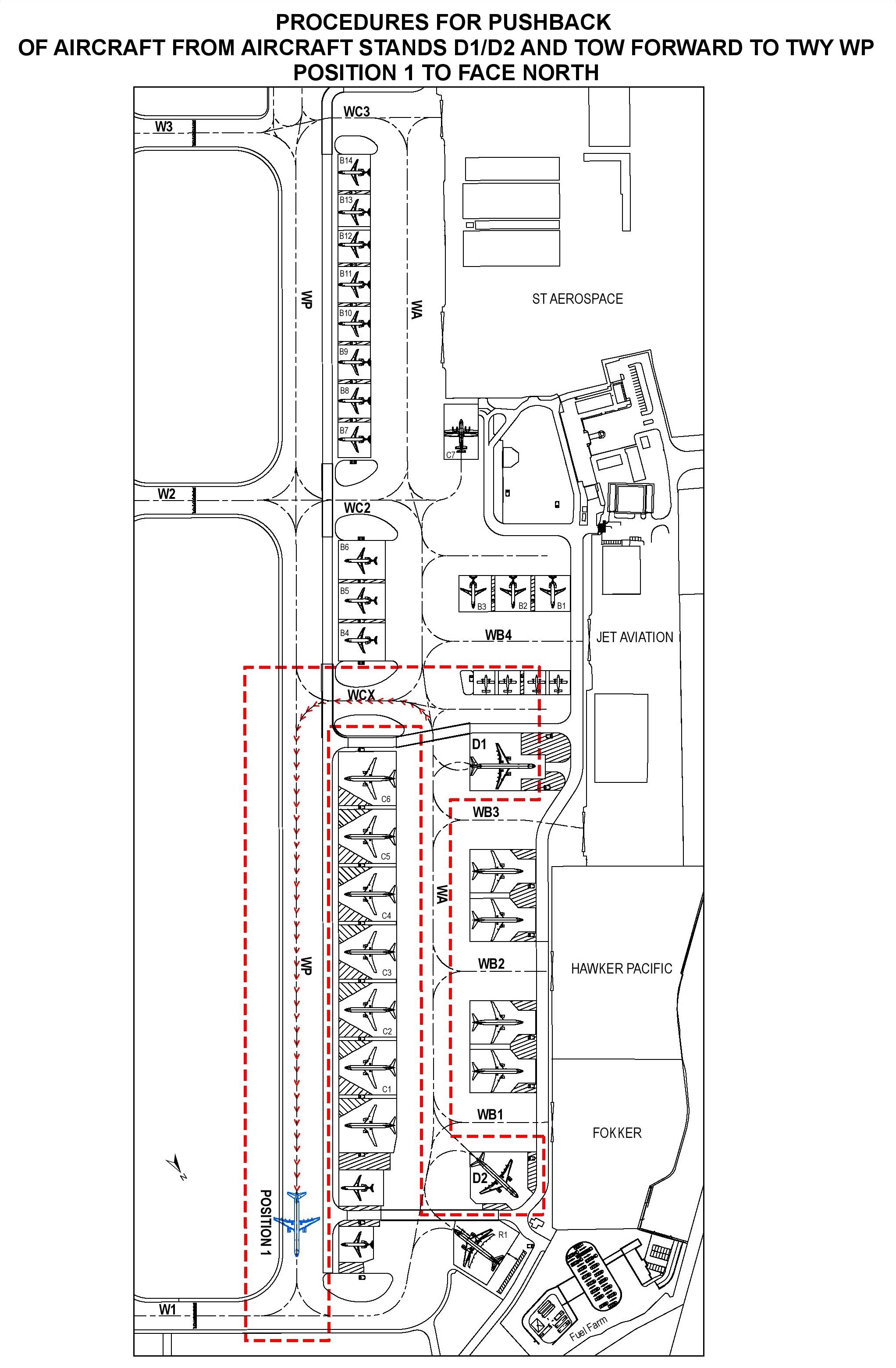
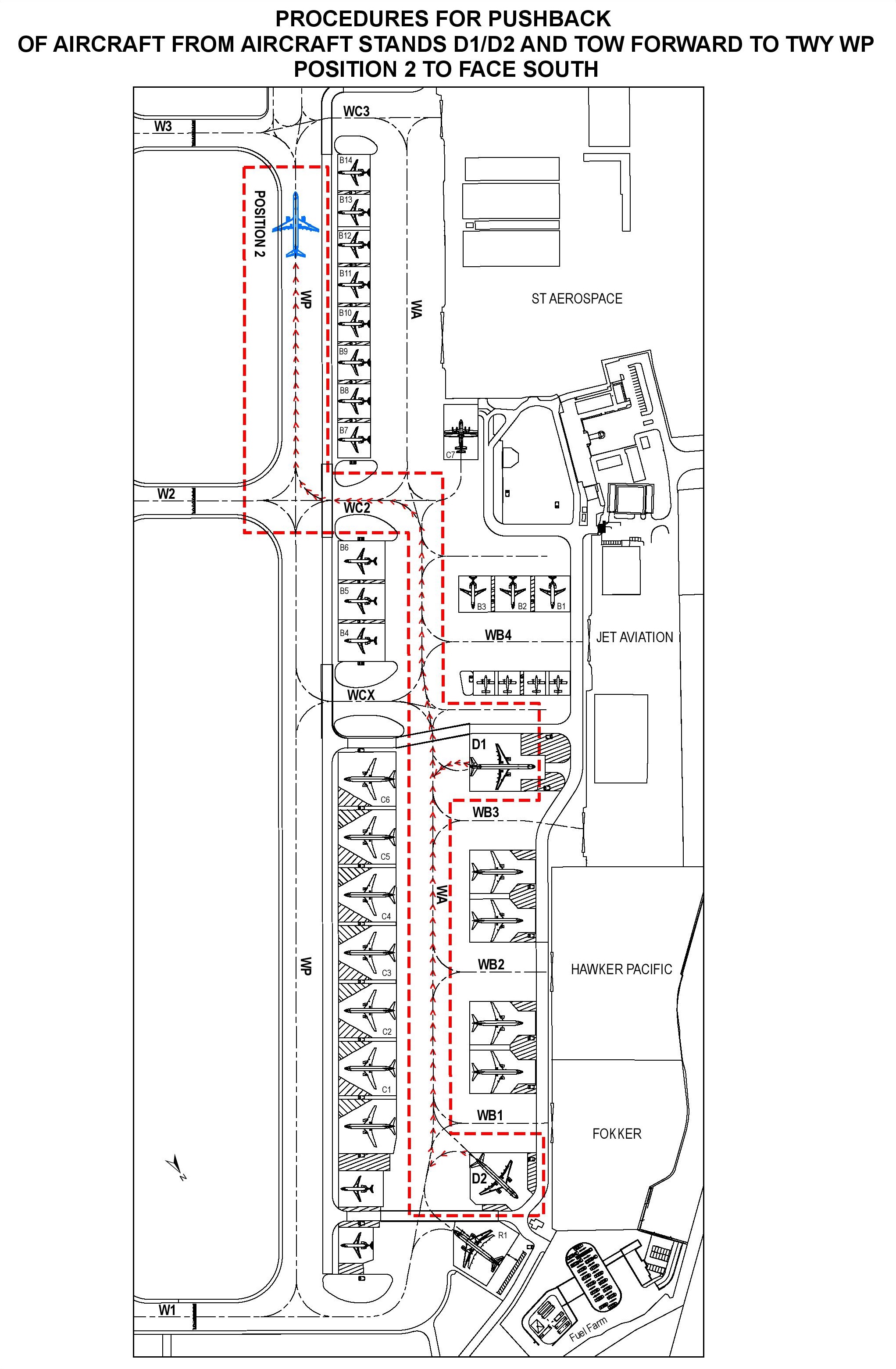
| D1/D2 (for B757-200 and C130) | PUSHBACK AND TOW FORWARD TO TWY WP | |
The tow-crew shall request from Seletar Ground (vehicular) on 122.9MHz for departure pushback approval. Upon receiving the approval, the aircraft shall be pushed back onto TWY WA to face South until its nose wheel is at the intersection of the aircraft stand lead-in line and TWY WA centreline. The aircraft shall then be towed forward to TWY WP until the tow tug towing the aircraft is at the intermediate holding position short of TWY W1 (see chart AD 2.WSSL-6) or TWY W3 (see chart AD 2.WSSL-7). Once the tow tug is disengaged, the aircraft will request start up approval from Seletar Ground (aircraft) on 121.6MHz. The aircraft shall breakaway from there. | 1) Tow approved to intermediate holding position on TWY WP short of TWY W1 to face North; or 2) Tow approved to intermediate holding position on TWY WP short of TWY W3 to face South | |
| FOR LANDED B757-200/C130 AIRCRAFT EXITING VIA TWY W1 | ||
After landing, B757-200/C130 aircraft exiting TWY W1 shall stop when its nose is at the information marking “B757/C130 HOLD FOR TOW” on TWY W1. The aircraft shall be on tow starting from this point onwards until they park inside the aircraft stands. | Not applicable | |
| FOR LANDED B757-200/C130 AIRCRAFT EXITING VIA TWY W2 | ||
After landing, B757-200/C130 aircraft exiting TWY W2 shall stop when its nose is at the information marking “B757/C130 HOLD FOR TOW” on TWY W2. The aircraft shall be on tow starting from this point onwards until they park inside the aircraft stands. | Not applicable | |
| FOR LANDED B757-200/C130 AIRCRAFT EXITING VIA TWY W3 | ||
After landing, B757-200/C130 aircraft exiting TWY W3 shall stop when its nose is at the information marking “B757/C130 HOLD FOR TOW” on TWY W3. The aircraft shall be on tow starting from this point onwards until they park inside the aircraft stands. | Not applicable | |
| D50 /D51/ D52/D53/ D54/D55/ D56 | The tow crew shall request from Seletar Ground (vehicular) on 122.9MHz for pushback approval. Upon receiving the approval, the aircraft shall be pushed back onto TWY EN to face South until its nose wheel is at the intersection of the aircraft stand pushback line and TWY EN centreline. The aircraft shall then be towed from there. | Pushback approved to face South |
| C60/C61 | Pushback to face North | |
The aircraft (on idle thrust) shall be pushed back onto TWY EC to face North until its nose wheel is abeam the centreline of aircraft stand C62. The aircraft may break away from there. | Pushback approved, to face North. | |
| Pushback to face East | ||
The aircraft (on idle thrust) shall be pushed back onto TWY EC2 to face East until its nose wheel is at the “EOP C60/C61” position. The aircraft may break away from there. | Pushback approved, to face East. | |
| C62 | Pushback to face North | |
The aircraft (on idle thrust) shall be pushed back onto TWY EC to face North until its nose wheel is at the “EOP C62” position. The aircraft may break away from there. | Pushback approved, to face North. | |
| Pushback to face South | ||
The aircraft (on idle thrust) shall be pushed back onto TWY EC to face South until its nose wheel is abeam the centreline of aircraft stand C61. The aircraft may break away from there. | Pushback approved, to face South. |
WSSL AD 2.10 AERODROME OBSTACLES
| IN APPROACH / TKOF AREAS | IN CIRCLING AREA AND AT AD | ||||
|---|---|---|---|---|---|
| RWY/Area affected | Obstacle type Elevation Markings/LGT | Coordinates | Obstacle type Elevation Markings/LGT | Coordinates | |
| a | b | c | a | b | |
| RWY 03 TKOF RWY 21 APCH | 1) Mast HGT ranging from 98ft AMSL and above in shipping channel | Approximately 1525m from THR RWY 21 | 1) Power station chimney 407ft AMSL | 012656.8N1035251.7E | |
| 2) Steel structure 300ft AMSL | 012709.78N1035318.74E | 2) Radio mast 217ft AMSL | 012258.8N1035113.8E | ||
| 3) Chimney 276ft AMSL | 012700.18N1035321.93E | 3) Radio masts 184ft AMSL | 012454N 1035300E | ||
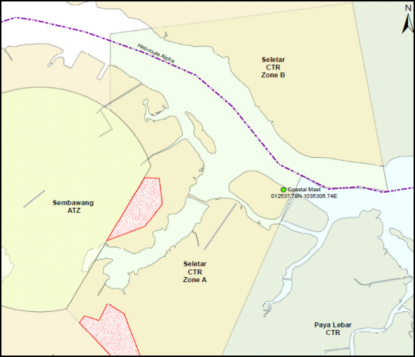
| 4) Chimney 273ft AMSL | 012651.81N1035330.23E | 4) Radar tower 177ft AMSL marked/LGTD | 012537.79N1035306.74E (reclaimed land north of RWY) | ||
| 5) Chimney 286ft AMSL | 012646.99N1035331.46E | 5) Mobile cranes 420ft AMSL | within area bounded by 012711.78N1035223.74E 012729.78N1035223.74E 012729.78N1035247.74E 012656.78N1035247.74E | ||
| 6) Mobile cranes 330ft AMSL | within area bounded by 012627.24N1035313.00E 012607.79N1035333.95E 012614.23N1035337.07E 012623.93N1035316.02E | 6) Glide Path Antenna 72ft AMSL | 012512N1035215E | ||
| 7) Silo, 342 ft AMSL, mark and lighted | 012659.1N1035325.3E | ||||
| Obstacles in the approach / TKOF areas, circling area and at the aerodrome are shown on the AOC and VAC | |||||
WSSL AD 2.11 METEOROLOGICAL INFORMATION PROVIDED
| 1 | Associated MET Office | Seletar |
| 2 | Hours of service | H24 |
| 3 | Office responsible for TAF preparation, Periods of validity | Singapore Changi, 30 hours |
| 4 | Type of landing forecast, Interval of issuance | METAR, SPECI and AD warning of adverse weather (H24). TREND NIL. |
| 5 | Briefing/consultation provided | NIL |
| 6 | Flight documentation, Language(s) used | Tabular forms, English |
| 7 | Charts/other information available for briefing or consultation | NIL |
| 8 | Supplementary equipment available for providing information | MDWR (Met Doppler Weather Radar) Maintenance Period: Second WED of every month between 0200-0900. In case of bad weather, THU following the second WED between 0200-0900. |
| 9 | ATS units provided with information | NIL |
| 10 | Additional information | TEL: 64815978 (MET Office) |
WSSL AD 2.12 RUNWAY PHYSICAL CHARACTERISTICS
| Designations RWY NR | TRUE BRG | Dimensions of RWY (m) | Strength (PCN) and Surface of RWY and SWY | THR coordinates (THR GEOID Undulation) | THR Elevation |
|---|---|---|---|---|---|
| 1 | 2 | 3 | 4 | 5 | 6 |
| 03 | 033.33° | 1836 x 46 | 44/F/C/X/T Bituminous Concrete | 012430.846N 1035143.791E (9.78M) | 14 M |
| 21 | 213.33° | 1836 x 46 | 44/F/C/X/T Bituminous Concrete | 012520.791N 1035216.425E (9.78M) | 5 M |
| RWY End Elevation | Highest Elevation of Touchdown Zone | CWY Dimensions | STRIP Dimensions (m) | OFZ | Remarks (continued below) |
|---|---|---|---|---|---|
| 7 | 8 | 9 | 10 | 11 | 12 |
| 5 M | 13 M | 60 M x 150 M | 1956 M x 150 M | Not applicable | RESA RWY 03 - 240m X 92m |
| 14 M | 10 M | RESA RWY 21 - 240m X 150m |
| 12 | Remarks: | |
i) Scheduled closure period for RWY 03/21
ii) A lighted RWY turn pad with centreline marking is provided at the threshold of RWY 03 which is able to serve aircraft up to B757-200. iii) Orange frangible posts are positioned along the boundary 90m on either sides of the RWY centreline demarcating the boundary for grass cutting and other maintenance works. iv) Wind Direction Indicators (WDIs) are located at both northern and southern ends of the RWY. | ||
WSSL AD 2.13 DECLARED DISTANCES
| RWY Designator | TORA(m) | TODA(m) | ASDA(m) | LDA(m) | Remarks |
|---|---|---|---|---|---|
| 1 | 2 | 3 | 4 | 5 | 6 |
| 03 | 1836 | 1896 | 1836 | 1836 | NIL |
| 21 | 1836 | 1896 | 1836 | 1836 | NIL |
WSSL AD 2.14 APPROACH AND RUNWAY LIGHTING
| RWY Designator | APCH LGT type LEN INTST | THR LGT Colour WBAR | VASIS (MEHT) PAPI | TDZ LGT LEN | RWY CL LGT,LEN, spacing, colour, INTST | RWY edge LGT LEN, spacing colour, INTST | RWY End LGT Colour WBAR | SWY LGT LEN Colour |
| 1 | 2 | 3 | 4 | 5 | 6 | 7 | 8 | 9 |
| 03 | Simple APCH LGT: 4 rows of barettes of 3 LGT each and 1 crossbar of 13 LGT. White, elevated, uni -directional APCH LGT and white, omni-directional CGL on top of elevated APCH LGT. Simple TDZ LGT: 2 pairs white, inset, uni-directional LGT. | Green with THR IDENT LGT | PAPI 3°(both sides of RWY) 2 white 2 red LGT (17.720m) 3 white 1 red LGT (20.323m) 4 white LGT (22.927m). ACFT with eye-to-wheel HGT greater than 6.3m are ADZ to fly with 2 white 2 red LGT visible so as to achieve sufficient wheel CLR. | NIL | NIL | White with yellow on last 600m of either end. Elevated, omni- directional and brilliancy controlled. | Red | NIL |
| 21 | APCH LGT: 1 row of inset APCH LGT of 4 LGT and 4 rows of barettes of 4 LGT each. White inset uni-directional APCH LGT and white omni-directional CGL on top of white, elevated uni-directional APCH LGT. Simple TDZ LGT: 2 pairs white, inset, uni-directional LGT. | Green with THR IDENT LGT | PAPI 3.5°(both sides of RWY) 2 white 2 red LGT (17.720m) 3 white 1 red LGT (19.286m) 4 white LGT (20.871m). ACFT with eye-to-wheel HGT greater than 6.3m are ADZ to fly with 2 white 2 red LGT visible so as to achieve sufficient wheel CLR. | NIL | NIL | White with yellow on last 600m of either end. Elevated, omni- directional and brilliancy controlled. | Red | NIL |
| RWY 21 THR and RWY END LGT symmetrically disposed in 2 groups with a gap between the groups. RWY 21 THR and RWY END LGT reinstated to inset fitting. | ||||||||
WSSL AD 2.15 OTHER LIGHTING, SECONDARY POWER SUPPLY
| 1 | ABN/IBN location, characteristics and hours of operation | ABN: 012448.000N 1035207.960E (on top of Control Tower) ALTN FLG W G EV 2.5 SEC. HN and IMC IBN: 012509.939N 1035152.143E (on top of West Substation) Flashing G ‘SL’ repeatedly. HN and IMC |
| 2 | LD and LGTI location Ultrasonic wind sensor location and LGT | Ultrasonic wind sensors and windsocks at ends of RWY. |
| 3 | TWY edge and centreline lighting | TWY Edge LGT: Blue, elevated and omni-directional. |
| 4 | Secondary power supply/switch-over time | Automatic standby generator power supply available for airfield lighting. |
| 5 | Remarks | Vehicles painted yellow or displaying checkered red/white or orange/white flag at highest point of vehicle. WDI lighted. |
WSSL AD 2.16 HELICOPTER LANDING AREA
| 1 | Coordinates of THR of FATO Geoid undulation |
| ||||||||||||
|---|---|---|---|---|---|---|---|---|---|---|---|---|---|---|
| 2 | FATO elevation M/FT | H03- 10.45m/34.3ft; H21 - 9.36m/30.7ft | ||||||||||||
| 3 | FATO area dimensions, surface, strength, marking | Rectangle 297m x 21.5m, compacted turf, helicopter landing area designations, outline by concrete kerbs painted white. | ||||||||||||
| 4 | True BRG of FATO | 033.33/213.33° Direction of TKOF zones: 034°GEO / 214°GEO | ||||||||||||
| 5 | Declared distance available |
| ||||||||||||
| 6 | Approach and FATO lighting | Nil | ||||||||||||
| 7 | Remarks | Slope of helicopter landing area (transverse/longitudinal) H03 - 1.19%/0.44% ; H21 - 0.96%/0.44% |
WSSL AD 2.17 ATS AIRSPACE
| 1 | Designation and Lateral Limits | SELETAR CTR SELETAR CONTROL ZONE A SELETAR CONTROL ZONE ‘B’ |
| 2 | Vertical Limits | SELETAR CONTROL ZONE A SELETAR CONTROL ZONE B |
| 3 | Airspace Classification | C |
| 4 | ATS Unit Call sign Language(s) | SELETAR TOWER English |
| 5 | Transition Altitude | 11000 FT (3,350m) |
| 6 | Remarks | NIL |
WSSL AD 2.18 ATS COMMUNICATION FACILITIES
| Service designation | Call sign | Frequency P-Pri S-Sec | Hours of operation | Remarks |
| TWR | Seletar Tower | P118.45 MHz S130.2 MHz 270.4 MHz | H24 | * for vehicular movements |
| Seletar Ground | 121.6 MHz * 122.9 MHz | |||
| ACC | Singapore Radar | P123.7 MHz S127.3 MHz | For AWY B469, G334, R208, L625, L629, L635, L642, M751, M753, M758, M761, M763, M771, N884, N891 and N892 | |
| 133.8 MHz | 0000-1430 | |||
| P133.25 MHz S135.8 MHz | H24 | For AWY A457, A464, A576, B466, L762, R325 (all northbound) and R469. | ||
| P134.2 MHz S133.35 MHz | For AWY G580, M646 and M767 | |||
| P134.4 MHz S128.1 MHz 255.4 MHz | For AWY A464, A576, G579 (all southbound), B470, G220, N875 and in area in the immediate vicinity of Singapore | |||
| Radar Maintenance Period: Monthly - every third SAT BTN 1601-2359 | ||||
| Singapore Radio | 6556 kHz 11297 kHz | SEA 1. SATCOM SER AVBL SSB suppressed carrier | ||
| 5655 kHz 8942 kHz 11396 kHz | SEA 2. SATCOM SER AVBL SSB suppressed carrier | |||
| 6556 kHz | SEA 3. SATCOM SER AVBL SSB suppressed carrier | |||
| APP | Singapore Approach | P120.3 MHz S124.6 MHz | TAR: a) Intermediate APCH to Singapore Changi AP and other airports in Singapore every first SAT BTN 1601-2359 (ASR I) and every fourth SAT BTN 1601-2359 (ASR II) | |
| Seletar Approach | 126.025 MHz | 0000-1500 | TAR - Intermediate and final approach to Seletar Airport |
WSSL AD 2.19 RADIO NAVIGATION AND LANDING AIDS
| Type of Aid and Variation | IDENT | Frequency | OPR Hour | Position of Transmitting Antenna Coordinates | DME Transmitting Antenna Elevation / Remarks |
| 1 | 2 | 3 | 4 | 5 | 6 & 7 |
| JAYBEE NDB | JB | 400 KHz (80w) | H24 | 012959.77N 1034241.82E | BRG 298° DIST 19.6km from ARP Seletar. Coverage 50NM. Unusable 285°-060° beyond 20NM. |
| KONG KONG NDB | KK | 286 KHz (70w) | H24 | 013117.76N 1035923.69E | BRG 049° DIST 17.7km from ARP Seletar. Coverage 50NM. Unusable 270°-010° beyond 30NM. |
| SELETAR NDB | SEL | 220 KHz | H24 | 012448.50N 1035210.16E | BRG 152° DIST 0.44km from ARP Seletar. Coverage 50NM. |
| RWY 21 ILS LLZ | SEL | 110.3 MHz | H24 | 012422.38N 1035138.28E | Located 309m (1014ft) from THR RWY 03, along RWY centreline. Course width 5.71°. EM: A0/A2. Maintenance Period: |
| RWY 21 ILS GP | - | 335 MHz | H24 | 012511.78N 1035214.97E | Located 255m (837ft) from THR RWY 21 on left side of the RWY, 114m (374ft) from RWY centreline. GP angle 3.5°. HGT of ILS Reference Datum: 16.2m (54ft) EM: A0/A2 |
| RWY 21 ILS DME | SEL | CH40X | H24 | 012511.78N 1035214.97E | DME co-located with GP. EM: P9 |
WSSL AD 2.20 LOCAL TRAFFIC REGULATIONS
1 LOCAL FLYING RESTRICTIONS:
Light aircraft 800ft (west of Seletar runway only);
Other aircraft 1,000ft - 1,500ft (west of Seletar runway only);
Helicopter-only area east of runway up to 600ft AGL
2 TEST/TRAINING FLIGHTS
- Aircraft identification;
- Name and contact number of pilot;
- Number of persons on board;
- ETD;
- Flight duration;
- Total endurance;
- Area of flight (Light Aircraft Training Areas A, B or C)
3 WRONG APPROACHES AND LANDINGS OF AIRCRAFT BOUND FOR SELETAR AERODROME AND SEMBAWANG MILITARY AERODROME
3.1 INTRODUCTION
3.2 POINTS TO BEAR IN MIND WHEN APPROACHING SELETAR AD OR SEMBAWANG AD
- The runways at Seletar and Sembawang are almost identically aligned. Extra vigilance, therefore, is required when approaching either aerodrome, or when commencing an approach to land.
- Make full use of available navigational and landing aids, and positively identify each aid used.
- Adhere strictly to the joining instructions issued by ATC.
3.3 AERODROME CHARACTERISTICS OF SELETAR AND SEMBAWANG AERODROMES
| Aeronautical Service | Seletar AD | Sembawang AD | Significant Differences and Remarks |
|---|---|---|---|
| RWY Designation | 03/21 | 05/23 | Exercise caution due to almost similar RWY alignment |
| Location | Adjacent to the Straits of Johor on the eastern bank of Seletar River. Seletar AD is situated APRX 3NM NW of Paya Lebar AP. | APRX 3NM west of Seletar AD and 3NM inland from the Straits of Johor | Seletar RWY commences almost from the edge of the shore. Also note that Sembawang AD is inland and not next to the sea. |
| RWY LGT | White/Amber RWY edge LGT | NIL | Sembawang AD has no RWY LGT |
| Approach LGT | Simple approach LGT available for RWY 03 approach, consisting of 4 rows of barettes and 1 crossbar (5th row). RWY 03 - white, elevated, uni-directional approach LGT and white, omni-directional CGL on top of elevated approach LGT. Approach LGT available for RWY 21 approach, consisting of 1 row of inset approach LGT (1st row) and 4 rows of barettes. RWY 21 - white, inset and elevated, uni-directional approach LGT and white, omni-directional CGL on top of elevated approach LGT. Simple touchdown zone LGT for both RWY 03 and RWY 21 approach consisting of 2 pairs of white, inset, uni-directional LGT | NIL | No visual approach slope indicator at Sembawang AD |
| IBN | Flashing Green ‘SL’ | Flashing R ‘AG’ EV 20 SEC HN and IMC | NIL |
| ABN | ALTN Flashing W G EV 2.5 SEC | NIL | Sembawang AD has no ABN |
| Parking Apron | Relatively large aircraft parking apron to the west of RWY, connected to the RWY by three taxiways | Small aircraft parking apron | Differences in size and location of the parking apron |
WSSL AD 2.21 NOISE ABATEMENT PROCEDURES
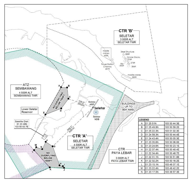
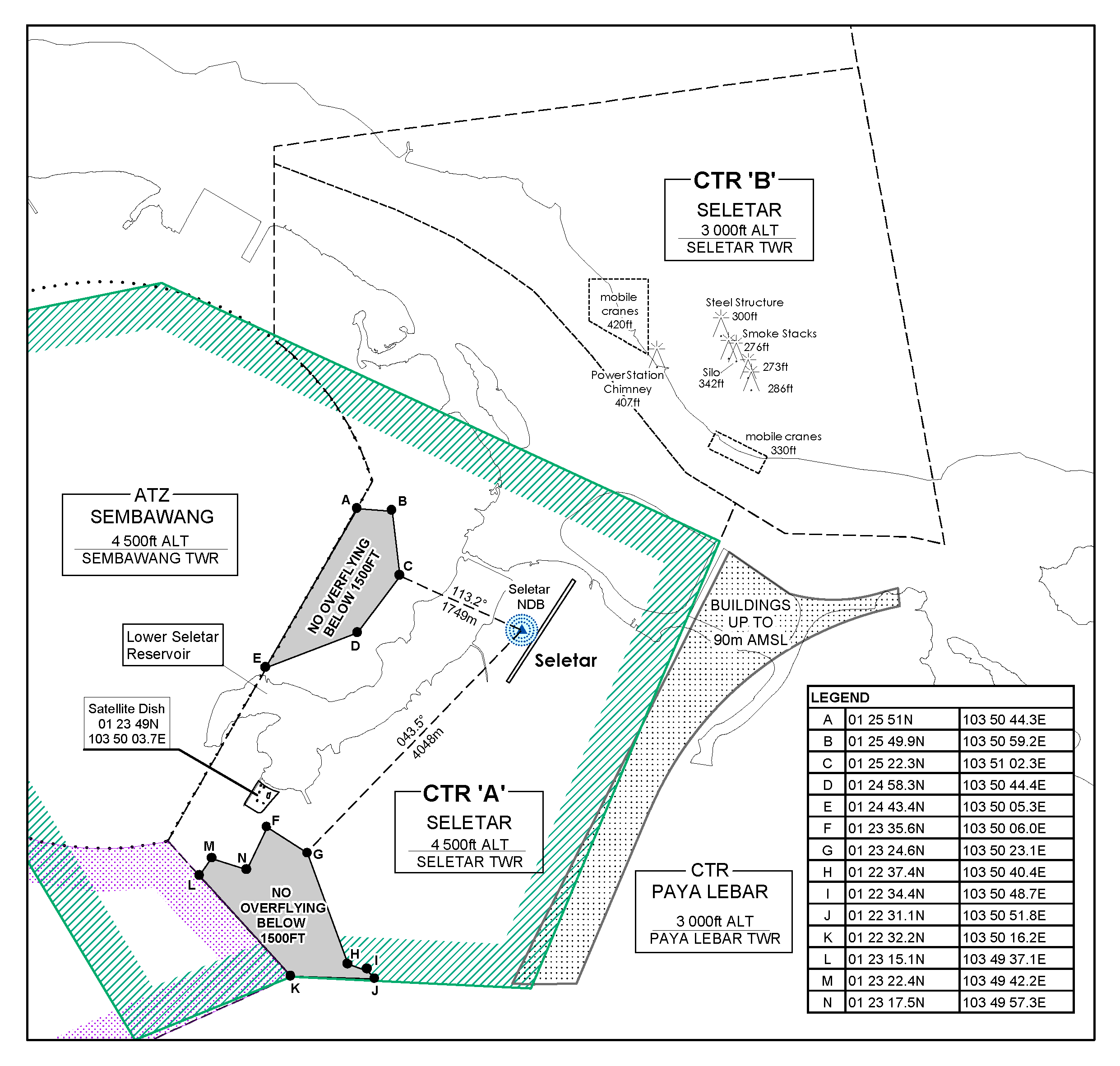
| POINT | COORDINATES |
|---|---|
| A | 012551.0N 1035044.3E |
| B | 012549.9N 1035059.2E |
| C | 012522.3N 1035102.3E |
| D | 012458.3N 1035044.4E |
| E | 012443.4N 1035005.3E |
| F | 012335.6N 1035006.0E |
| G | 012324.6N 1035023.1E |
| H | 012237.4N 1035040.4E |
| I | 012234.4N 1035048.7E |
| J | 012231.1N 1035051.8E |
| K | 012232.2N 1035016.2E |
| L | 012315.1N 1034937.1E |
| M | 012322.4N 1034942.2E |
| N | 012317.5N 1034957.3E |
WSSL AD 2.22 FLIGHT PROCEDURES
1 PROCEDURES FOR ARRIVALS INTO SELETAR AERODROME
1.1 Introduction
1.2 Joining Procedures for VFR flights from Tebrau City Mall (013259N1034748E)
- AD-2-WSSL-VAC-1 : Visual Approach Chart - RWY 03
- AD-2-WSSL-VAC-2 : Visual Approach Chart - RWY 21
1.3 Joining Procedures from Light Aircraft Training Areas
- AD-2-WSSL-VAC-1: Visual Approach Chart - RWY 03
- AD-2-WSSL-VAC-2: Visual Approach Chart - RWY 21
1.4 Joining Procedures for IFR flights from KK or JB - RWY 03
Cross KK at or above 3,000ft. On passing KK descend in VMC to 2,000ft or altitude cleared by ATC and join downwind RWY 03.
- Straight-in-Approach
Join downwind RWY 03 at 2,000ft (keeping clear of Sembawang ATZ). When downwind descend from 2,000ft for visual approach RWY 03, or as cleared by ATC. Pilots should have the runway in sight. - Circling Approach
Join downwind RWY 03 at 2,000ft (keeping clear of Sembawang ATZ). At end of downwind turn left and overfly the runway. When passing over Position A (north end of the runway), descend from 2,000ft to 1,500ft and turn left for downwind RWY 03. At downwind descend for a visual approach RWY 03 or as cleared by ATC. Pilots should have the runway in sight.
Cross JB at or above 6,000ft enroute to Point ALFA. On passing Point ALFA, descend in VMC to 2,000ft or altitude cleared by ATC. (Point ALFA is located at 013033N 1034942E or Radial 296/7 DME VTK)
- Straight-in-approach
On passing Point ALFA, turn right for downwind RWY 03 (keeping clear of Sembawang ATZ). At downwind descend from 2,000ft for a visual approach RWY 03, or as cleared by ATC. Pilots should have the runway in sight. - Circling Approach
On passing Point ALFA, turn right for downwind RWY 03 (keeping clear of Sembawang ATZ). At end of downwind, turn left and overfly the runway. Passing over Position A (north end of the runway), descend from 2,000ft to 1,500ft and turn left for downwind RWY 03. At downwind descend for a visual approach RWY 03 or as cleared by ATC. Pilots should have the runway in sight. Procedures are illustrated in the following charts:- AD-2-WSSL-VAC-3 : Visual Approach Chart - RWY 03
- AD-2-WSSL-IFR-1 : Seletar Aerodrome joining Procedures (IFR flights) from JB and KK - RWY 03
1.5 Joining Procedures for IFR flights from KK or JB - RWY 21
Cross KK at or above 3,000ft. On passing KK descend in VMC to 2,000ft or altitude cleared by ATC.
- Straight-in-Approach
Join direct for a straight-in visual approach Rwy 21 descending from 2,000ft, or as cleared by ATC. Pilots should have the runway in sight.
- Circling Approach
Overfly the runway at 2,000ft, or as cleared by ATC. Passing over Position A (the south-end of the runway), descend from 2,000ft to 1,500ft and turn right for downwind RWY 21 (keeping clear of Light Aircraft Training Area A and Sembawang ATZ). At downwind descend for a visual approach RWY 21 or as cleared by ATC. Pilots should have the runway in sight.
Cross JB at or above 6,000ft enroute to Point ALFA. On passing Point ALFA, descend in VMC to 2,000ft or altitude cleared by ATC. (Point ALFA is loc at 013033N 1034942E or Radial 296 VTK)
- Straight-in-approach
On passing Point ALFA, join direct for a straight-in visual approach RWY 21 descending from 2,000ft, or as cleared by ATC (keeping clear of Sembawang ATZ).
- Circling Approach
On passing Point ALFA, overfly the runway at 2,000ft. When passing over Position A (the south end of the RWY), descend from 2,000ft to 1,500ft and turn right for downwind RWY 21 (keeping clear of Light Aircraft Training Area A and Sembawang ATZ). At downwind descend for a visual approach RWY 21 or as cleared by ATC. Pilots should have the runway in sight. Procedures are illustrated in the following charts:
- AD-2-WSSL-VAC-4 : Visual Approach Chart - RWY 21
- AD-2-WSSL-IFR-2 : Seletar Aerodrome Joining Procedures (IFR flights) from JB and KK - RWY 21
1.6 Holding Procedure
1.7 Approaches to Seletar Aerodrome
2 DEPARTURES FROM SELETAR AERODROME
WSSL AD 2.23 ADDITIONAL INFORMATION
1 BIRD CONCENTRATION IN THE VICINITY OF THE AIRPORT
- Cattle egrets (weighing approximately 300g each)
- Brahminy kites (weighing approximately 600g each)
2 HELICOPTER CROSSING SELETAR NORTHERN EXTENDED CENTRELINE
WSSL AD 2.24 CHARTS RELATED TO SELETAR AIRPORT
